Kaitlyn Dunnett/Kathy Lynn Emerson here, today talking about maps. I love maps. They are so much better than GPS—but that’s another story.

When I was writing historical novels, I searched for every map I could find, both contemporary and historical, trying to make sure my locations were as accurate as I could make them. When I create a fictional place, whether it’s a house or a whole town (or even a whole county) I need to sketch it out on paper to see where things are in relation to one another. I am no artist, but I can use a ruler and a pencil, so I make floor plans for my houses and road maps for my towns. I’d love to have these appear in my published books, but so far only the ones I wrote as Kate Emerson have included professionally drawn maps. I’m given to understand that such things are expensive, and since I have no talent in that area myself, it doesn’t seem likely any will appear in the Kaitlyn Dunnett novels.

That said, a while back a reader named Mark Roberts sent me a message on Facebook and included his map of downtown Moosetookalook, based on reading several of the Liss MacCrimmon mysteries. He wanted to know if it was accurate.

It wasn’t far off, and it triggered an exchange of emails that resulted in my sending him a copy of my amateurish sketch. Mark offered to turn it into a proper map of the area around the town square. Of course I accepted. What writer wouldn’t?
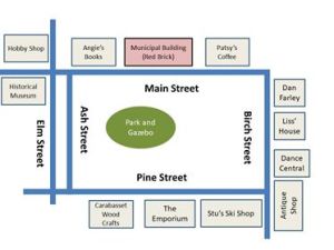
The project was complicated by the fact that several of the shops around the town square have had more than one owner. Amazing how many murderers and murder victims there have been in that part of town! We wanted to avoid spoilers, but it would have been confusing to put just the current owner (as of the eleventh book, X Marks the Scot) or only who occupied them in the first (Kilt Dead), so Mark had to devise a way to show all the owners (to date—who knows who will end up dead or in jail in future books?). The other problems was that, like most towns that have been around for a couple of hundred years, Moosetookalook’s streets don’t form a perfect grid. They curve. They go off at odd angles. That said, the streets around the town square are more uniform than most. They get downright twisty for the part of Moosetookalook not shown on the downtown map. Mark did a wonderful job and you can see the final result at the top of this post.

My “working” map of all of Moosetookalook is drawn on a desk-blotter size piece of graph paper taped to the back of my office door. It’s in pencil, because I make changes in it from time to time, as well as lots of additions. It comes in handy when I forget where I’ve put a minor character’s house or a grocery store. And, truthfully, since I’m directionally challenged, it helps to have that map handy when I can’t remember if Liss should turn left or right when she leaves Moosetookalook Scottish Emporium to go to The Spruces.

What about you, readers? Do you still use road maps, or has modern technology taken their place? Do you like to find maps of fictional places in the novels you read? And if there are none, do you ever draw one for yourself?

Kathy Lynn Emerson/Kaitlyn Dunnett is the author of more than fifty-five traditionally published books written under several names. She won the Agatha Award and was an Anthony and Macavity finalist for best mystery nonfiction of 2008 for How to Write Killer Historical Mysteries and was an Agatha Award finalist in 2015 in the best mystery short story category. She was the Malice Domestic Guest of Honor in 2014. Currently she writes the contemporary Liss MacCrimmon Mysteries and the “Deadly Edits” series (Crime & Punctuation—2018) as Kaitlyn and the historical Mistress Jaffrey Mysteries (Murder in a Cornish Alehouse) as Kathy. The latter series is a spin-off from her earlier “Face Down” mysteries and is set in Elizabethan England. Her most recent collection of short stories is Different Times, Different Crimes. Her websites are www.KaitlynDunnett.com and www.KathyLynnEmerson.com and she maintains a website about women who lived in England between 1485 and 1603 at A Who’s Who of Tudor Women.


 Kait Carson

 Charlene D’Avanzo


I don’t have GPS, so use maps, mostly old ones, and sometimes I’ll Google directions/routes/maps. I love maps as part of books, whether part of the text on on the inside of the book covers. I’ve read a lot of Faulkner and he made good, inventive use of maps:
http://people.virginia.edu/~sfr/FAULKNER/09mapsf.html
For a historical, crime, noir, thriller novel I’ve written, set in 1960 northern, industrial New Jersey, I’ve relied on my own experiences and memories, the latter more frayed and gauzy as time goes on. Plus, for whatever sense of “place” I’ve attained, I used a 2000 AAA New York City and vicinity roadmap, with more of northern New Jersey, actually, than NYC, Bronx, Brooklyn and Queesn. It’s now more scotch tape than paper. When I needed more detail I used online searches for area treets, places and images.
My GPS and I have an agreement. She stays in the glovebox and I don’t yell at her. I have always preferred maps. They give you a sense of location and relationship to your surroundings that you can’t get from that little follow-the-line-turn-here-and-here of a GPS. The pockets of my car are filled with maps. I mostly travel rural roads and need to know how they connect to each other.
The first action I took after my marriage was to write a letter to the area Chambers of Commerce for information and maps. Only one didn’t send a map. They wanted a whole dollar for a copy. Hence, I wouldn’t patronize that city for years. It was the principle of the thing, of course. If you want me to shop your city, give me a map.
Our county court house has maps dating back to the original plats. Combing over them is a fun way to spend an afternoon. Maps in books are a special treat. If I open a book and maps are printed on the inside of the cover, it’s an invitation to purchase! And I have been known to sketch a map to help keep things straight.
So, yep, I use maps, enjoy maps, and draw them when necessary. A big thank you to Mark for recreating the map for you.
It’s hard when you’re writing about a long-past century like 1689 Boston, but I’ve got one map that dates about 30 years older, and Boston streets haven’t changed that much around the Commons. Our favorite restaurant, the Union Oyster House, has been shucking oysters at the bar since the early 1700’s. Boston still has the atmosphere I need for my nosy Puritans series.
Maybe someone could do a book of maps for all the different fictional towns like yours. I would definitely buy it!